Photo: Saint-Jean-Pied-de-Port and the Nive by LPLT, CC BY-SA 3.0, via Wikimedia Commons

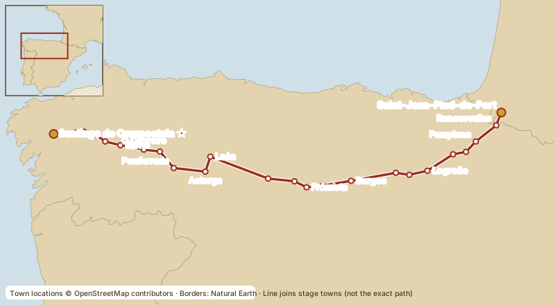
The most historic and most walked route, described in the 12th-century Codex Calixtinus. It crosses Navarra, La Rioja, Castilla y León and Galicia, through Pamplona, Burgos and León. Its biggest drawback is crowding, especially from Sarria onward.
Stage outline (Gronze)
| # | Stage | km |
|---|---|---|
| 1 | Saint-Jean-Pied-de-Port → Roncesvalles (Napoleon route over the Pyrenees) | 24.2 |
| 1B | Saint-Jean → Roncesvalles (Valcarlos road, lower and safer in bad weather) | 23.4 |
| 2 | Roncesvalles → Zubiri | 21.4 |
| 3 | Zubiri → Pamplona | 20.4 |
| 4–11 | Pamplona → Puente la Reina → Estella → Los Arcos → Logroño → Nájera → Santo Domingo → Belorado → San Juan de Ortega | |
| 12 | → Burgos | |
| 13–20 | The Meseta: Hornillos → Castrojeriz → Frómista → Carrión → Terradillos → Bercianos → Mansilla → León | |
| 21–28 | León → Astorga → Foncebadón (Cruz de Ferro) → Ponferrada → Villafranca → O Cebreiro → Triacastela → Sarria | |
| 29–33 | Sarria → Portomarín → Palas de Rei → Arzúa → O Pedrouzo → Santiago | ~114 |
| Full kilometre table: Gronze, Camino Francés. |
Good to know
- Day 1 is the hardest: about 1,200 m of climbing over the Pyrenees. In winter the Napoleon route is officially closed; take the Valcarlos road.
- Short on time? Sarria to Santiago (~114 km, 5 days) earns the Compostela. 67% of Francés pilgrims start there, so it's busy.
- Getting to the start: fly to Biarritz or Bordeaux → train to Bayonne → train/bus to Saint-Jean-Pied-de-Port; or Madrid → Pamplona → bus.
Deep Dive
History and origins
The cult of St James grew after a tomb near the Galician coast was identified, in the early 9th century, as that of the Apostle; the bishop Teodomiro of Iria Flavia is credited with the discovery and King Alfonso II of Asturias with the first church over it. That the tomb is truly St James's is a matter of faith and tradition; that pilgrims came in growing numbers is history. The earliest pilgrim known by name is Gotescalco (Godescalc), bishop of Le Puy, who travelled in 950–951.
The road we call the Francés took shape in the 11th century, when Sancho III of Navarre shifted it south onto the line through Puente la Reina, Estella, Logroño and Nájera, and Alfonso VI of León and Castile consolidated it with bridges, hospitals, toll exemptions and new towns for pilgrims and settlers, many of them "Franks" from beyond the Pyrenees. Around 1135–1145 the Codex Calixtinus (Liber Sancti Jacobi) was compiled; its fifth book, the so-called Pilgrim's Guide, describes this route stage by stage. In 1993 UNESCO inscribed the Camino Francés as a World Heritage Site, and the French approach routes followed in 1998.
Regions crossed
From the French Basque Country the road enters Navarra, where Basque (Euskara) is still heard in the Pyrenean valleys, then the wine country of La Rioja, the vast region of Castilla y León (the provinces of Burgos, Palencia and León) and finally Galicia (Lugo and A Coruña), where signs switch to Galician. The food changes with the land: Navarrese vegetables and pochas beans, Rioja wine and lamb chops grilled over vine cuttings, the roast suckling lamb and morcilla of Burgos, León's cecina (cured beef) and the botillo of El Bierzo, then Galicia's pulpo á feira, Arzúa-Ulloa cheese and tarta de Santiago.
Elevation and landscape
Day one is the big one: the Napoleon route climbs from under 200 m at Saint-Jean to about 1,430 m at the Col de Lepoeder before dropping to Roncesvalles. After Burgos comes the Meseta, a high plateau of wheat fields mostly between 750 and 900 m, open, windy and long. The route's highest point is the Cruz de Ferro in the Montes de León, at around 1,500 m, followed by a steep descent into the green basin of El Bierzo. The last great climb is up to O Cebreiro (about 1,300 m) and on past the Alto do Poio, after which Galicia is a rolling country of oak woods, granite villages and frequent rain. Guides disagree on total ascent because they measure differently, so we don't quote a single figure.
Notable past travellers
- Gotescalco of Le Puy (950–951): the earliest pilgrim to Santiago known by name, documented in a manuscript copied for him at the monastery of Albelda.
- The author of the Pilgrim's Guide (c. 1140): often attributed to the French cleric Aymeric Picaud, but the attribution is contested: the text names an "Aymericus", and Picaud appears only in later additions.
- Hermann Künig von Vach (1495): a German Servite friar whose rhymed guidebook was printed for German pilgrims.
- Domenico Laffi: a priest from Bologna who walked the route several times and published a vivid account, Viaggio in Ponente a S. Giacomo di Galitia e Finisterrae, first printed in Bologna in 1673.
- Francis of Assisi (tradition): Franciscan tradition says he made the pilgrimage around 1213–1215, but there is no contemporary documentary proof.
Notable stops
- Roncesvalles: Augustinian collegiate church and pilgrim hospital, tied by legend to Roland's last stand in the Song of Roland.
- Pamplona: walled city of the San Fermín festival, entered over the medieval Magdalena bridge.
- Puente la Reina: where the routes from Somport and Roncesvalles meet, crossing an 11th-century six-arched bridge.
- Santo Domingo de la Calzada: the cathedral keeps a live hen and rooster in memory of the miracle of the hanged pilgrim, a famous legend.
- Burgos: its Gothic cathedral is a World Heritage Site in its own right (since 1984).
- León: the Cathedral's stained glass and the Royal Pantheon of San Isidoro, with its 12th-century frescoes.
- Astorga: Roman walls and Gaudí's Episcopal Palace.
- Cruz de Ferro: pilgrims leave a stone from home at the foot of an iron cross on a tall pole.
- O Cebreiro: thatched pallozas and the church linked to a medieval Eucharistic miracle legend.
- Sarria: the most popular start for those walking the last 100 km.
Sources
- Government of Navarre, Decision 13732E/2025 on the Napoleon route (Saint-Jean 154 m, Lepoeder 1,432 m)
- Xunta de Galicia: O Cebreiro–Triacastela stage (O Cebreiro ~1,300 m, Alto do Poio 1,337 m)
- Xacopedia: Cruz de Ferro (1,504 m)
- Xacopedia: Gotescalco (950–951)
- Xacopedia: Camino Francés (Sancho III's realignment)
- Xacopedia: Alfonso VI
- Ad Limina 9 (2018): who wrote the Pilgrim's Guide? (Aymericus attribution)
- University of Salamanca Historical Library: Künig's 1495 guide
- Fundación Jacobea: Domenico Laffi (1673)
- Xunta de Galicia: from the first pilgrims to today
- UNESCO: Routes of Santiago de Compostela: Camino Francés and Routes of Northern Spain
- UNESCO: Routes of Santiago de Compostela in France
- UNESCO: Burgos Cathedral
- UNESCO: Santiago de Compostela (Old Town)
- Xunta de Galicia official Camino site: French Way
- Official Pilgrim's Office (Oficina del Peregrino)
- Pilgrim's Office: the Compostela certificate
- Cathedral of Santiago de Compostela (official)
- Oficina del Peregrino, statistics 2025 (route shares, via santiago.es summary)
- santiago.es: every Camino route side by side
- pilgrim.es route list · Seis Caminos route list
- Gronze.com (stage-by-stage planning)
⚠ Guides differ by a few kilometres because of variants and measuring methods. Distances are shown as ranges.
Last verified: October 15, 2026. Prices, hours and rules change: confirm with the official source before you go.