Photo: Seville Cathedral and the Giralda by Azukiki, CC BY-SA 3.0, via Wikimedia Commons

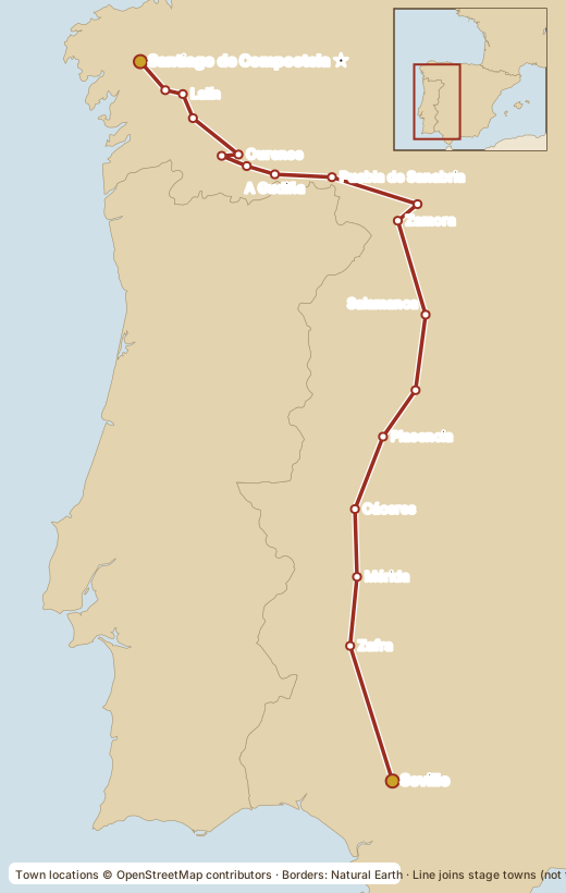
The longest and loneliest route, following a Roman road north through Mérida, Cáceres, Salamanca and Zamora, then the Camino Sanabrés via Ourense. Long stages between villages and extreme summer heat in Extremadura. About half of its pilgrims actually start in Ourense (~105 km) and only one in five from Seville.
Good to know
- Best seasons: spring and autumn. Avoid June to August in the south.
- Fly into Seville (SVQ).
Deep Dive
History and origins
The route follows much of the Roman road that linked Emerita Augusta (Mérida) with Asturica Augusta (Astorga), whose stations are recorded in the Roman Antonine Itinerary (generally dated to the 3rd century), though not as a single named road. Roman milestones still stand along it. The name has nothing to do with silver as far as anyone can prove: a traditional explanation derives "Plata" from the Arabic balat (paved road), but scholars do not agree, and other proposals include the Latin delapidata ("paved with stone"). In the Middle Ages, Christians living under Muslim rule (Mozarabs) and later southern pilgrims used it to go north. The route was revived as a pilgrim road in the late 20th century, with associations of the Camino marking it with yellow arrows and opening albergues; it remains one of the least crowded routes. North of Zamora, many pilgrims follow the Camino Sanabrés to Ourense and Santiago, while others continue to Astorga to join the Francés.
Regions crossed
From Andalusia (Seville) the route crosses Extremadura (Badajoz and Cáceres), then Castilla y León (Salamanca and Zamora) and finally Galicia (Ourense and Pontevedra, then A Coruña). The landscapes and food change: Andalusian gazpacho and tapas, Extremadura's jamón ibérico from acorn-fed pigs and Torta del Casar cheese, Salamanca's hornazo (meat pie), Zamora's rice dishes and Toro wine, and Galician lacón con grelos and Ribeiro wine.
Elevation and landscape
The south is flat and hot: wide plains, cork oak and holm oak pastures (dehesa), and long stretches without towns. North of Plasencia the route climbs to the Puerto de Béjar and the Castilian plateau around Salamanca and Zamora, mostly between 700 and 900 m. The highest passes come on the Sanabrés, at Padornelo and A Canda, at roughly 1,340 m and 1,260 m respectively, before descending into Galicia's valleys toward Ourense.
The Roman heritage is visible: stretches of the old road, granite milestones and bridges such as Mérida's long Roman bridge over the Guadiana. Distances between villages can be long in Extremadura, so carrying enough water and planning each stage matters more here than on the busier routes. In return, many pilgrims find the solitude and the wide sky the best part of the journey. Summer heat in Extremadura is extreme, so most pilgrims walk in spring or autumn.
Notable past travellers
The Via de la Plata is better documented as a road than through individual pilgrims. The Roman route is described in the Antonine Itinerary. Medieval pilgrims from the south are known through hospitals and confraternities rather than named personal accounts.
Notable stops
- Seville: the cathedral (with the Giralda) is a World Heritage Site and holds the tomb of Columbus.
- Zafra: a whitewashed town with arcaded squares.
- Mérida: Roman theatre, amphitheatre and bridge; the Archaeological Ensemble is a World Heritage Site.
- Cáceres: a walled old town, listed by UNESCO.
- Arco de Cáparra: a four-sided Roman arch in open countryside, near the route.
- Salamanca: its old town and university are a World Heritage Site; the Plaza Mayor is a highlight.
- Zamora: a city of Romanesque churches.
- Puebla de Sanabria: a castle town at the edge of the mountains.
- Ourense: the cathedral and hot springs (As Burgas) where Romans bathed.
- Baños de Montemayor: a spa town with Roman baths, at the climb toward the Puerto de Béjar.
- Granja de Moreruela: where most pilgrims leave the Plata for the Camino Sanabrés; the ruins of the Cistercian monastery of Moreruela lie nearby.
- Laza and Xunqueira de Ambía: Galician villages on the way to Ourense; Laza is known for its carnival (Entroido).
- Lalín and Silleda: inland Galician towns in the final days before Santiago.
Sources
- Junta de Castilla y León: La Vía de la Plata (Roman road and milestones)
- Spanish Ministry of Culture, National Museum of Roman Art: toponymy of the Vía de la Plata (origin of the name)
- Xacopedia: Puerto de Padornelo
- Guiarutas: Camino Sanabrés (Padornelo and A Canda altitudes)
- UNESCO: Cathedral, Alcázar and Archivo de Indias in Seville
- UNESCO: Archaeological Ensemble of Mérida
- UNESCO: Old Town of Cáceres
- UNESCO: Old City of Salamanca
- UNESCO: Santiago de Compostela (Old Town)
- Xunta de Galicia official Camino site: Vía de la Plata
- Official Pilgrim's Office (Oficina del Peregrino)
- Pilgrim's Office: the Compostela certificate
- Cathedral of Santiago de Compostela (official)
- Oficina del Peregrino, statistics 2025 (route shares, via santiago.es summary)
- santiago.es: every Camino route side by side
- pilgrim.es route list · Seis Caminos route list
- Gronze.com (stage-by-stage planning)
⚠ Guides differ by a few kilometres because of variants and measuring methods. Distances are shown as ranges.
Last verified: October 15, 2026. Prices, hours and rules change: confirm with the official source before you go.